


2026 Hurricane Forecasts
NOAA - 6 August 2026
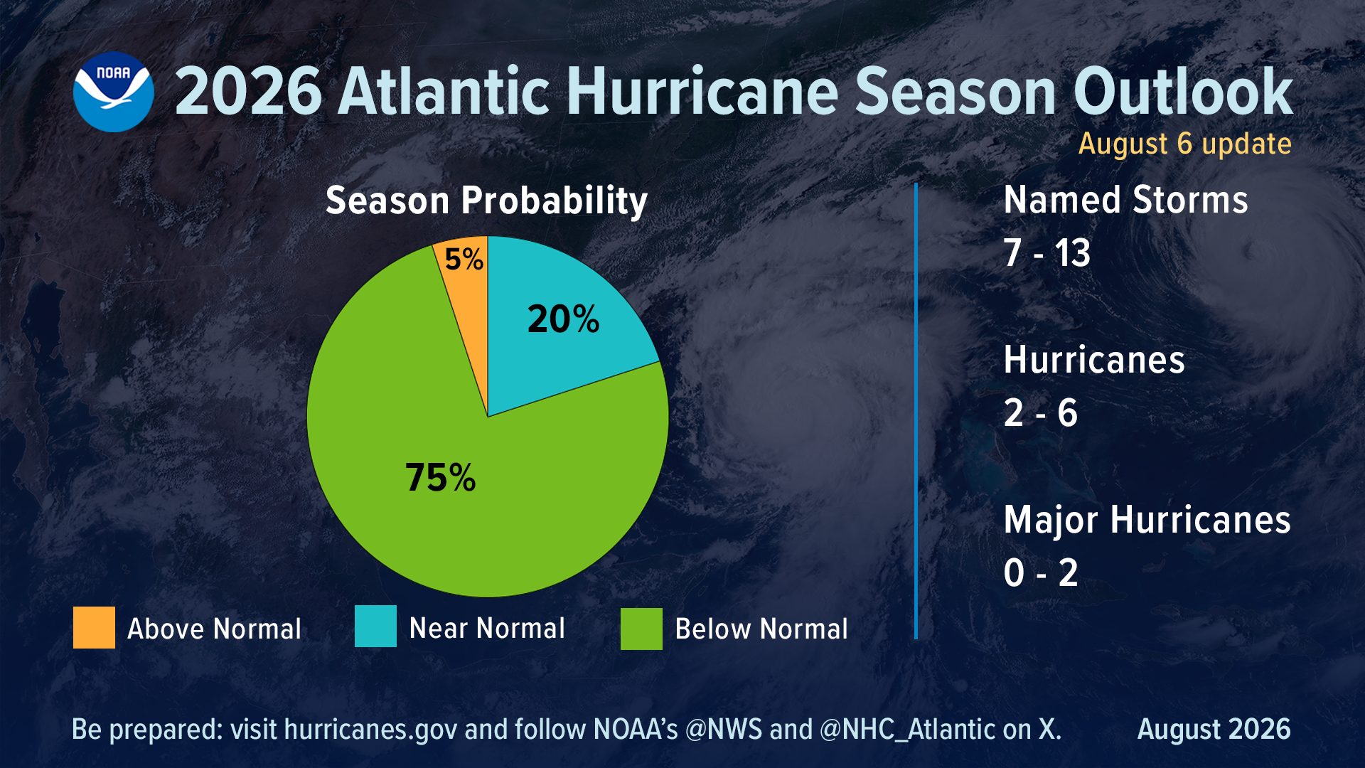
To date, the 2026 season has produced two named tropical storms, Arthur and Bertha, and no hurricanes. NOAA forecasters predict a 75% chance for below-normal activity, with a 20% chance of a near-normal season, and just a 5% chance of above-normal activity.
The official NOAA El Nino-Southern Oscillation (ENSO) outlook indicates a 90% chance that El Nino conditions will occur during the Northern Hemisphere fall and winter 2026-27. The current hurricane season outlook reflects the expectation that El Nino conditions will interfere with the set of conditions associated with Atlantic hurricanes. El Nino is an oscillating climate pattern that affects weather conditions in the United States and has historically been associated with fewer Atlantic storms.
Colorado State University - 5 August 2026
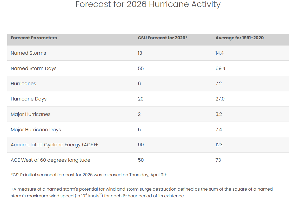
We anticipate El Nino being the dominant factor for the upcoming hurricane season, driving increased levels of tropical Atlantic vertical wind shear. We are forecasting a below-average probability for major hurricane landfalls along the continental United States coastline and in the Caribbean.
The Weather Channel - 16 April 2026
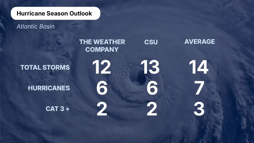
An El Nino is expected to be ongoing, potentially even reaching super El Nino levels. El Ninos occurring during the Atlantic hurricane season often lead to increased wind shear in the Atlantic Basin. Increased shear, or changes in wind speed and direction in the atmosphere, hinder hurricane development. El Nino conditions also lead to more widespread sinking air in the Atlantic, which further hinders development.
Accuweather - 25 March 2026
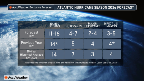
The 2026 Atlantic hurricane season will be shaped by a shifting climate pattern in the Pacific Ocean. Typically, El Nino creates stronger upper-level winds (wind shear) across the Atlantic, making it harder for tropical storms to take shape. With El Nino forecast to develop and strengthen throughout the summer and autumn, it is likely to translate to fewer storms during the second half of the hurricane season compared to the first half.
There is about a 15% chance that a "super El Nino" will develop if ocean temperatures near the equator of the eastern Pacific rise at least 2 degrees Celsius (3.6 degrees Fahrenheit) above long-term averages. If it does happen, it could sharply reduce storm activity in late October and November.
The northern and northeastern Gulf Coast and the Carolinas face the highest threat of direct impacts. Rapid intensification is a risk - very warm Atlantic water could still allow storms to intensify quickly, including before the season officially begins on June 1.
Crown Weather Services - 21 March 2026
All indications seem to be pointing towards that this hurricane season may be below average in terms of the number of storms that occur. It appears that a moderate El Nino will develop by this summer and then possibly trend towards a strong El Nino by this autumn. Should this occur, it would lead to the atmospheric state to be unfavorable for tropical storms and hurricanes to form in the deep tropical Atlantic and the Caribbean. This means that any tropical storms or hurricanes that do form would probably do so in the Atlantic north of 20 North Latitude, as well as in the Gulf.
TV Station Affiliates of Hearst Communications - 2 March 2026
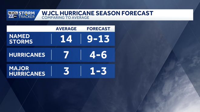
NOAA's forecast for peak hurricane season shows a 50%+ chance of an El Nino developing. Typically, the presence of an El Nino during hurricane season can limit or suppress tropical development.
Tropical Storm Risk (Euro Tempest) - 11 December 2025
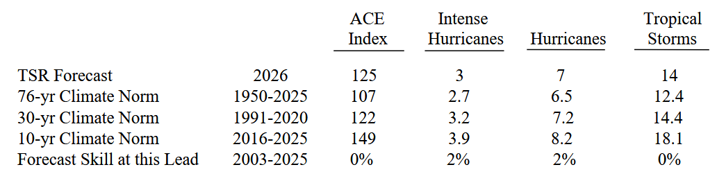
Historically the skill of the early December extended range forecast for North Atlantic hurricane activity is low.